 We have had numerous customers over the years ask a simple question, “Why do you always just troll south?”
It is a great question, and based on many years of fishing experience, our answer was, “We catch more fish when we troll south.”
But why that was the case wasn’t always clear, and now we have a tool that can help explain, along with show why this is the case.
It is based on the currents!
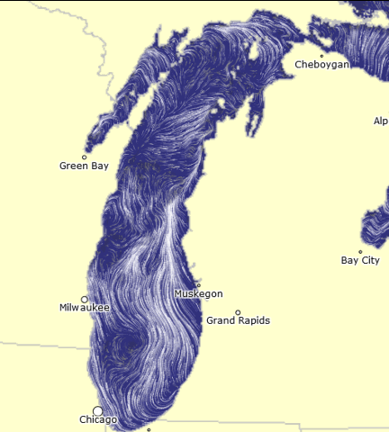
A new tool is now available online that is provided shows flow patterns depicted in visualizations of lake currents are based on simulations from the Great Lakes Coastal Forecasting System operated by NOAA’s Great Lakes Environmental Research Laboratory.
While in rare cases, the currents along the coast of West Michigan travel other directions than from south to north, most of the time, both on the surface, and more importantly, at depth, they follow this path. Trolling south means that we are trolling into the current and getting optimum “action” on the baits that we are fishing.
As we troll into the current, we are more capable of getting our baits to run at the best speeds for fish to bite. This speed varies to some degree depending on the type of fish we are targeting, and we use sensors at depth on our lines to best fine tune the exact speed, but it is most effectively done when traveling into the current.
The tool that is available online shows both currents on the surface and at depth. You can even review historic currents on dates or over monthly averages to look at how the currents travel throughout the summer fishing seasons. Overall, a pretty cool tool.
So the answer to the question can now be visually seen. We troll south because the currents come from there and by trolling south, we are almost always heading into the current!
Does this mean we will always have currents that run from the south to the north? No, not always. But it is the most common direction. Historically when this tool was not available, we would work to determine current direction using underwater speed indicators and compare that data with surface GPS tracks or surface current. With this tool, we can get a good idea of what the currents are doing before we even go out. And in the event that the currents are different, consider if on a particular day a troll other than on a southerly heading might be needed to be most successful.
Want to play with the tool? Visit this link to see even more – http://www.glerl.noaa.gov/res/glcfs/currents/